
DRIVE
INNOVATION
 Take control of the way you work. Scanning, imaging, processing, and sharing at
speed and scale. Trimble Mobile Mapping technology unlocks the next generation of geospatial projects.
Take control of the way you work. Scanning, imaging, processing, and sharing at
speed and scale. Trimble Mobile Mapping technology unlocks the next generation of geospatial projects.

-
Straßen.NRW — the road construction administration of the state of North Rhine-Westphalia — uses the Trimble MX9 mobile mapping solution to acquire data for the planning, building, and maintaining of the classified road network. With the MX9 it is possible to work efficiently while complying with the very strict safety requirements for working on roads in road traffic. Using data collected with the MX9, plans can be created, clearance heights of bridges for the planning of large and heavy transports calculated, or noise protection measures derived.
Bernd Geenen, Surveying Engineer, StrassenNRW
-
The use of Trimble MX9 mobile mapping technology has greatly improved accuracy, speed and safety of geospatial smart data collection as base of "digital twin" of Dubai, the happiest city in the World.
Maryam Almheiri, Director of GIS Center at Dubai Municipality
-
Mobile mapping captures everything once, allowing us to fix minor things easily and effectively without having to return to the field. We use mobile mapping technology because it's the right tool in the box to cover large distances accurately. What it does best in my opinion, is limit the amount of time on the side of the road making it safer for our crews and the public at large.
Bradford Folta, GIS Architect & CEO, Honey Badger Analytics LLC.
-
We used the Trimble MX9 in one of our pilot digitization projects to record the as-built of a railway line directly on and next to the track during regular, scheduled operation. The simplicity of the system and the recording of all areas thanks to the MX9's butterfly configuration impressed us. What we appreciate about Trimble's mobile mapping and scan systems is the openness of the data format they use for measurement results. This enables us to use software we already have in-house, that are used for other applications, for further data analysis.
Dr Helge Grafinger, Project Manager Products & Innovations, Rhomberg Sersa Rail Group
-
With Trimble's MX9 system, we are sure to have a system that is calibrated and at the same time suitable for any occasion (car, train, boat) with a very short installation time in any case. The opportunities have surprised us, and new opportunities continue to arise as we work with the system.
Anders Nygaard Møller, Partner & Land Inspector, LE34
-
Global Raymac adopted mobile mapping with a Trimble MX9 to provide our customers a more detailed survey collected unobtrusively and much faster than conventional methods ever will. Moreover, it's all about safety and the MX9 alleviates the need for exposing surveyors on dangerous highways.
Steaphan MacAulay, VP Transportation & Infrastructure, Global Raymac
-
Mobile mapping enables us to efficiently capture extensive and highly detailed inventory data without having to disrupt road traffic. This significantly increases safety for our staff and other road users while at the same time reducing costs, since complex road blocks are no longer necessary and recordings are completed in a shorter time.
Thomas Gröninger, Division Manager of Digitization, Strabag
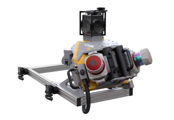
TRIMBLE MX9
The Trimble MX9 combines a very high point cloud density with immersive imagery, allowing you to quickly and efficiently survey a large project area at highway speed.
Download Brochure View Datasheet View Application Overview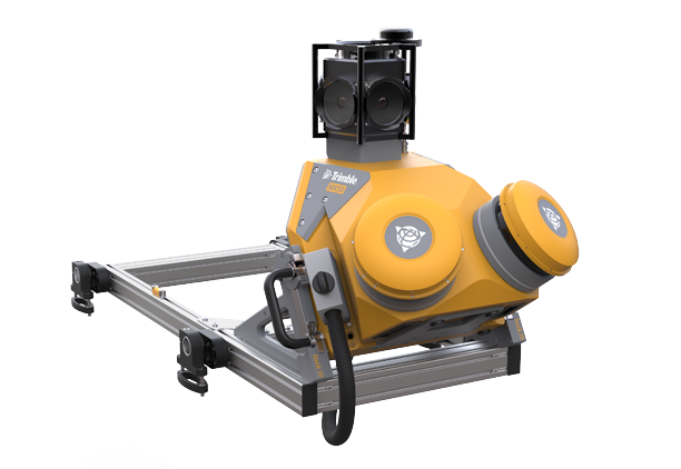
TRIMBLE MX50
The Trimble MX50 is a practical field-to-finish mobile mapping solution for asset management, mapping, and road maintenance. The system delivers a very accurate point cloud of the environment along with complimentary immersive imagery providing substantial gains in productivity.
Download Brochure View Datasheet View Application Overview
TRIMBLE MX7
Trimble MX7 captures detailed 360° geo-referenced images at highway speeds, providing a compact and easy-to-use alternative to traditional environmental image capture.
Download Brochure View Datasheet View Application OverviewMOBILE MAPPING RESOURCES

Customer StorySTRABAGRead how one German company has adopted Trimble MX9 to bring speed, safety and optimal data capture to its complex infrastructure projects. Read More

Customer StoryLE34Learn how a Danish survey company used Trimble MX9 to complete a railway engineering survey project in record time and to one-centimeter precision.Read More

Customer StoryATDRead how a Denver company used Trimble MX7 to inventory and image every Denver bus stop for an upgrade project with record speed and efficiency.Read More
Customer Stories
Charlotte Water - Mobile Mapping Sees It All
City of Amsterdam - Captured Once, Used Often
City of Dubai - A Seriously Smart Path to Happiness
Ditesco - Managing Rish In Fiber-To-Home Construction
Eagle GIS - Wheeling Out A New Mapping Approach
LE34 - Breaking The Centimeter Barrier
Mapillary - Adding Accuracy and Efficiency to Street-Level Imagery
Strabag AG - See It, Scan It, Map It: The Ease & Accuracy of Mobile Mapping
Vermessung AVT - Pushing Limits In The Alps
Webinars
How 3D Mobile Mapping brings Efficiency, Safety and Precision to Complex Engineering Projects
Optimization of GIS Data Collection and Asset Management with Advanced Trimble Mobile Mapping Solutions
Office and Field Validation for Mobile Mapping derived 3D Data
Land Mobile Mapping for Rail Applications
Trimble Business Center & Trimble MX Workflows to Support Fiber to the Home Operations
Trimble Mobile Mapping Webinar Center
PUT YOUR DATA TO WORK
Use Trimble Mobile mapping software to realize the true power of your geospatial data.
-
Trimble Business Center allows for Mobile Mapping data to be easily integrated with all other geospatial data for seamless workflows and data analytics.
Explore Trimble Business Center -
Trimble MX software helps you organize your data and extract relevant features and measurements.
Explore Trimble MX -
Utilize Trimble MX Publisher and enable multiple users to access and use the data for visualization, measurement, and local feature extraction.
Explore Trimble MX
-
Mobile MappingPORTFOLIO BROCHURELearn More
-
SpecificationsPRODUCT COMPARISONLearn More
-
Mobile MappingSOLUTIONS WEBPAGELearn More

WANT TO LEARN MORE?
Let us show you how Trimble mobile mapping solutions can help grow your business.
Give us a little information about yourself and your needs and a Trimble Mobile Mapping specialist will reach out to you personally.
Trimble Geospatial provides solutions that allow you to make your mark using high-quality, productive
workflows and information exchange, driving value for a global and diverse customer base of surveyors,
engineering, and GIS service companies, governments, utilities, and transportation authorities. Trimble's
innovative technologies include integrated sensors, field applications, real-time communications, and
office software for processing, modeling, and data analytics. We're pioneering the future of data
intelligence, converging people, product, and place seamlessly to help you make your mark and leave your
legacy.
More
about Trimble Inc.


